Documentation

How every screen in the app works. Importing telemetry CSVs, building an ideal lap, interpreting results, and exporting back to Wintax, WinDarab, or MoTeC.

Quick Start

If you already have telemetry data exported as CSV, follow this workflow to create an ideal lap.

  1. 1 Activate your license (first run only).
  2. 2 Select a folder containing CSV lap files (single-lap or multi-lap exports).
  3. 3 Choose a preset (if detected) or assign channels manually.
  4. 4 Review loaded laps and remove invalid laps (in/out laps are flagged).
  5. 5 Create segments (manual equal-distance or auto-detect from braking), then fine-tune boundaries on the track.
  6. 6 Analyze to build the ideal lap, then Export as CSV.
What you get
  • Ideal Lap Time — theoretical best
  • Best Actual Lap — fastest complete lap
  • Segment Sources — which lap each best segment came from
  • Actionable target — where you can realistically improve

The ideal lap is theoretical. Use it as a coaching target and compare segment sources to understand which approach was faster.

Core Concepts

Ideal Lap
Best segments combined

Built by taking the fastest elapsed time through each segment from any lap in your dataset, then summing those best segment times.

Segments
Your analysis grid

Segments divide the lap by distance so the app can compare apples-to-apples across laps. Use manual equal-distance splits or auto-detect tuned to braking events.

Sources
Where time came from

Every best segment has a source lap. That source information is the coaching value: it shows which lap had the best approach in each portion of the track.

App Screens

The app is a guided flow. Every screen and dialog is explained below.
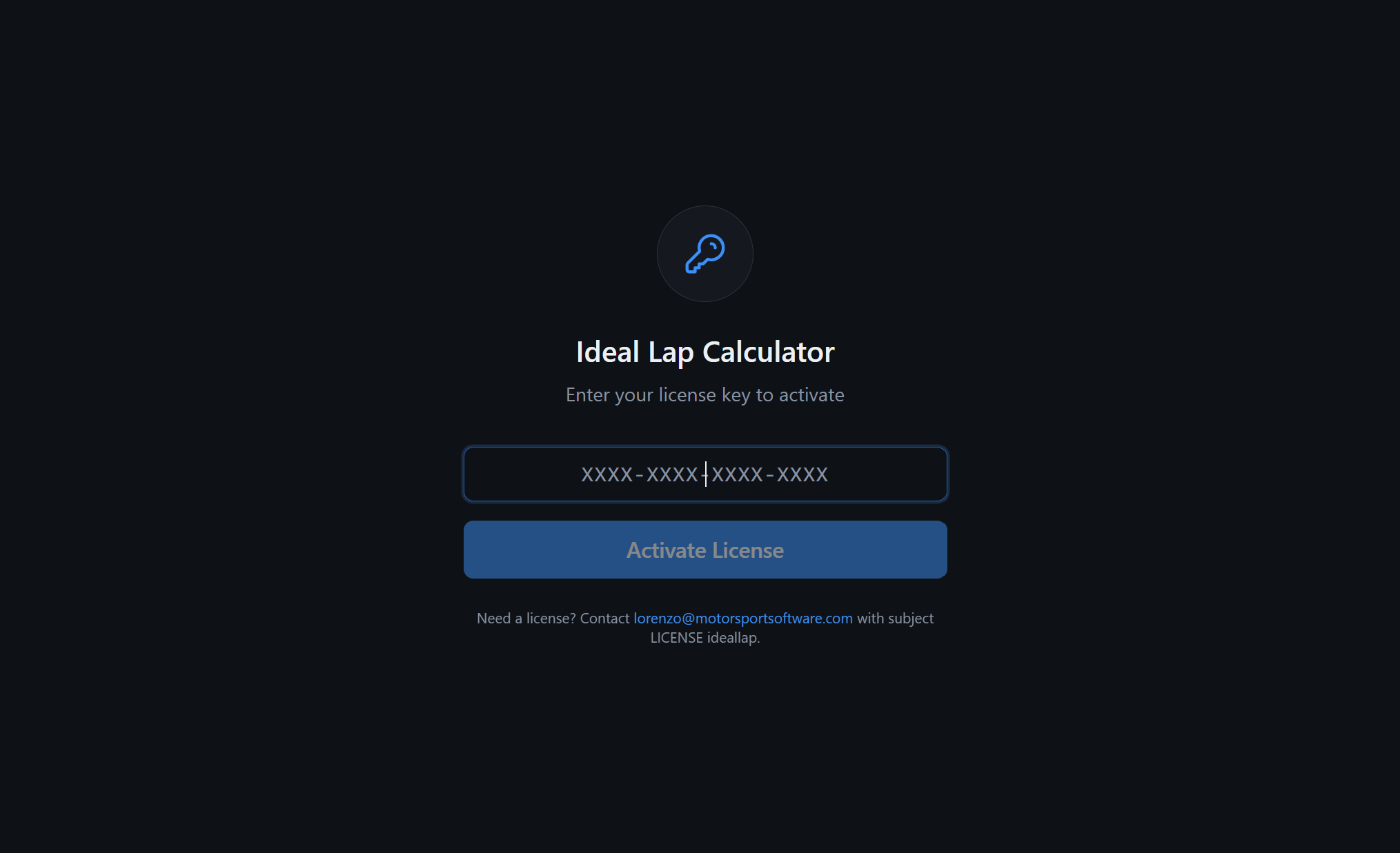
Screen 1

License Activation

On first launch (or when no valid license is found), enter your key in the format XXXX-XXXX-XXXX-XXXX and click Activate License.

What to do
  • Paste/enter the key (dashes are auto-formatted).
  • Press Enter to activate when complete.
  • If activation fails, confirm the key and internet connectivity.
What it means
  • Licensing controls access to the desktop app.
  • Once activated, you can proceed to data loading.
  • Some licenses support a limited offline grace period.
License activation screen
Screen 2

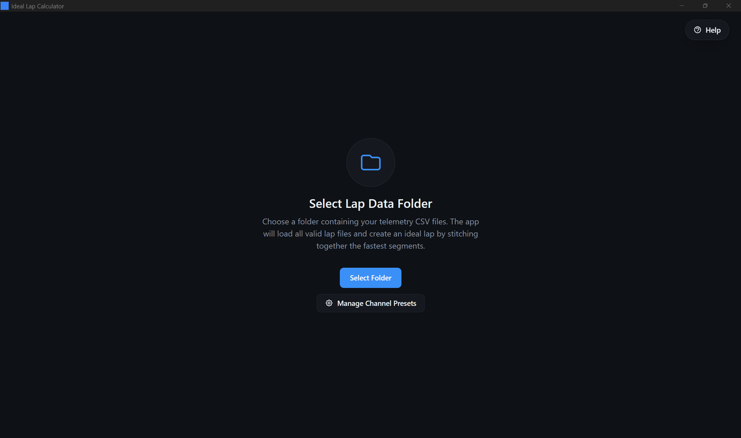
Select Lap Data Folder

Choose a directory containing your telemetry CSV files. The app reads all CSV files in the folder (ignoring its own exports), detects the CSV format, and prepares the data for analysis.

Buttons on this screen
  • Select Folder: opens your OS folder picker.
  • Channel Assignment: review and adjust detected channels before loading all laps.
Select lap data folder screen
Dialog

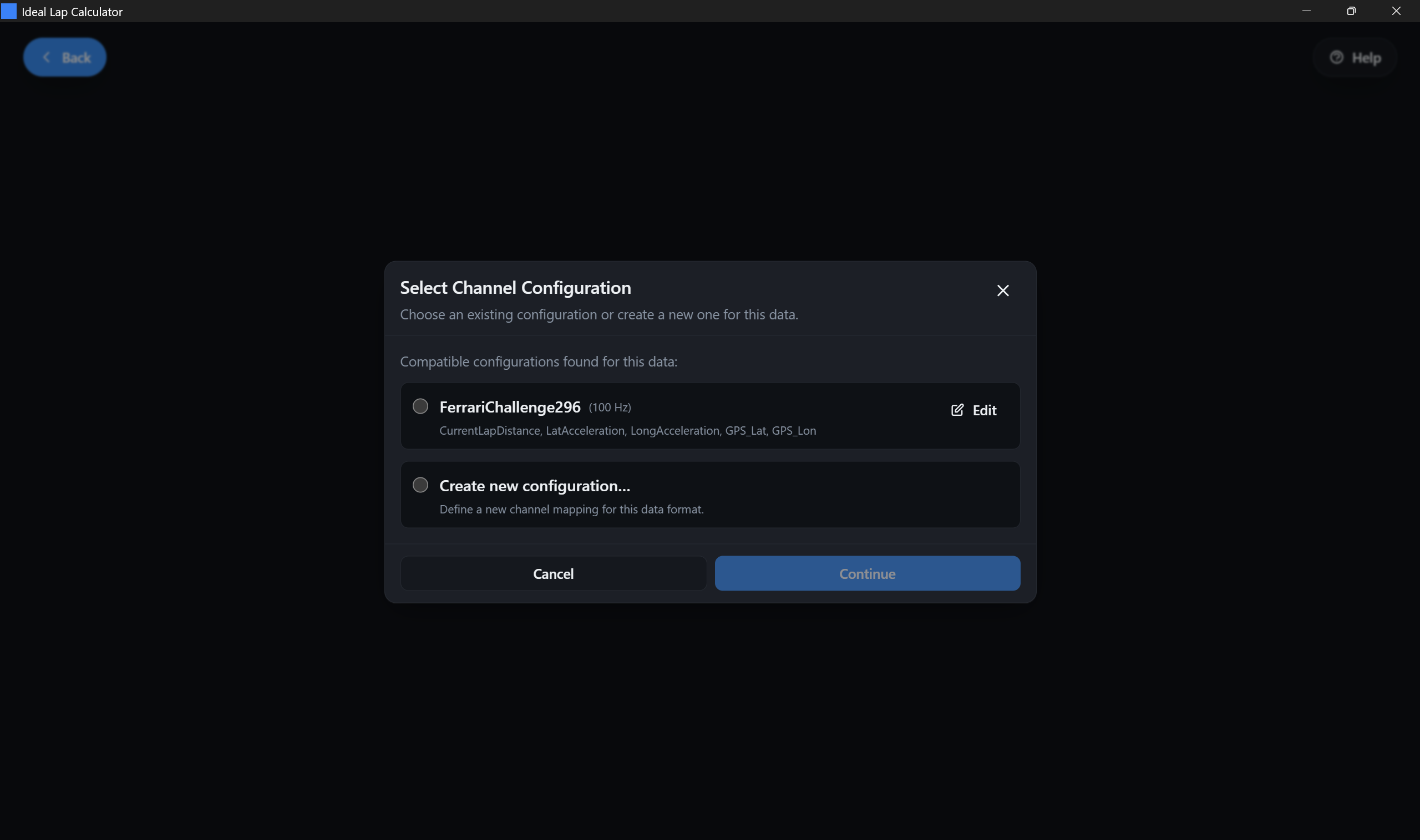
Select Channel Configuration (Preset)

When your CSV headers match one or more known mappings, the app lists compatible presets. Pick one to load laps quickly, or choose Create new configuration... to map columns manually.

Good to know
  • Presets can be built-in or custom.
  • Presets may display a sampling frequency (used when no Time column exists).
  • You can edit a preset before continuing.
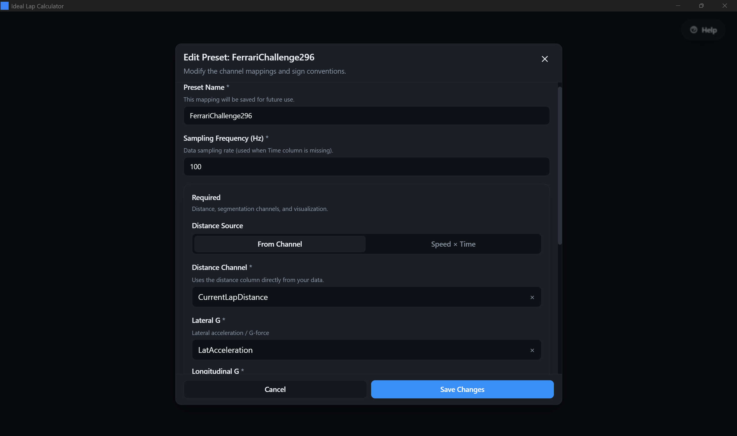
Preset selection dialog
Dialog

Channel Assignment

This is the most important setup screen. You map your CSV column names to the channels the app needs for segmentation, timing, and track visualization. A correct channel assignment is the difference between clean results and confusing results.

Required mapping
  • Distance source: from a distance column or calculated from Speed x Time.
  • Lateral G: optional for segmentation; used as reconstructed-track fallback when yaw rate is unavailable.
  • Longitudinal G: used for auto-segmentation and braking visualization on the track.
  • Track visualization: GPS lat/lon or reconstructed mode (requires Speed; yaw rate improves quality if available).
Advanced options
  • Sign conventions: fix channels where "left/right" or "brake/accel" are inverted.
  • Unit overrides: force km/h vs m/s, G vs m/s², meters vs feet, deg/s vs rad/s.
  • Lap number (optional): required for multi-lap CSVs to split laps reliably.
Note

For "Reconstructed" track mode, the app uses available telemetry channels to draw a usable track map when GPS is not present. Accuracy depends on your data quality and channel correctness.

Channel assignment dialog
Screen 3

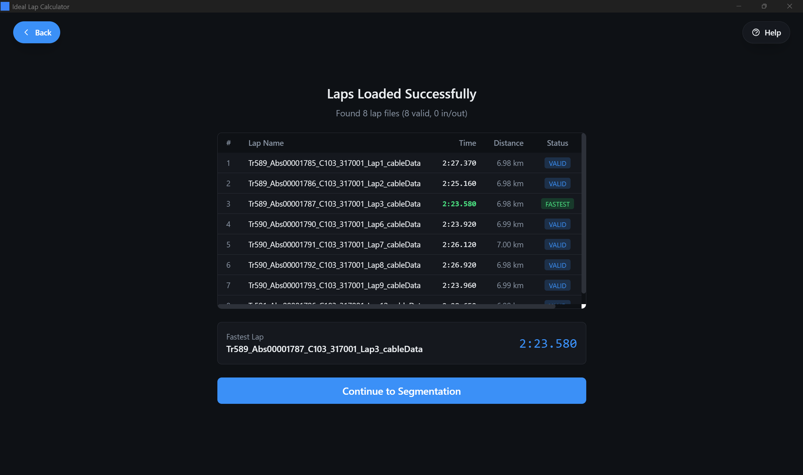
Laps Loaded Successfully

After data loading, the app shows a lap table. It highlights the fastest valid lap and flags laps that look like in/out laps (usually much slower than the median).

What you can do here
  • Confirm the number of laps and their lap times.
  • Remove any lap that should not be part of the ideal lap set (offs, traffic, invalid runs).
  • If the track layout fails to generate, fix channel mapping and reload.
Laps loaded summary screen
Screen 4

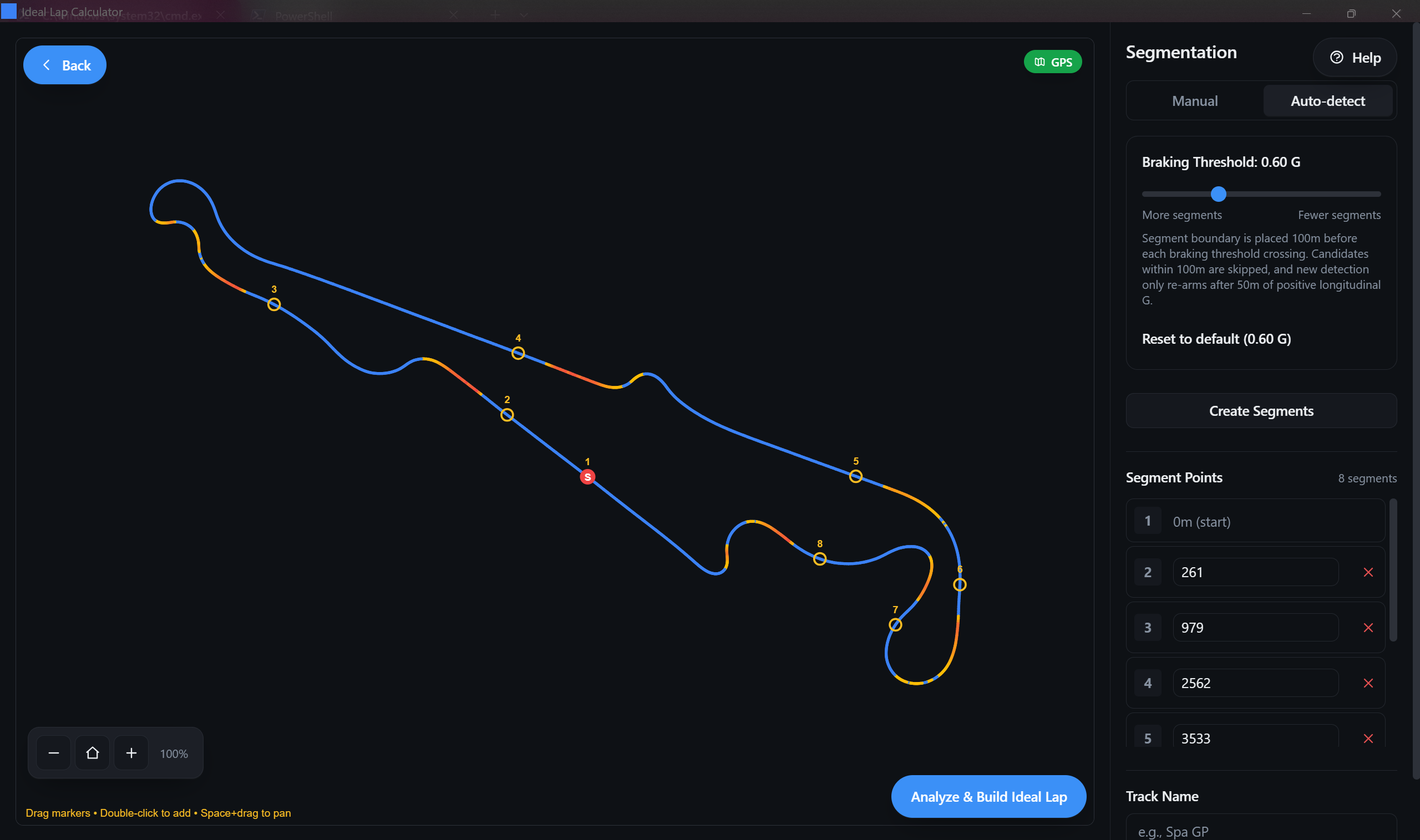
Segmentation & Track Editor

Create, edit, and validate segments. The left side shows a track canvas with interactive boundaries. The right side shows segmentation controls and a segment list editor.

Track canvas controls
  • Drag markers to move boundaries.
  • Double-click to add a boundary at that point.
  • Space + drag to pan.
  • Use the zoom buttons to zoom in/out and reset view.
  • A badge indicates track source (GPS vs non-GPS mode).
Segment creation
  • Manual: by count or by distance length.
  • Auto-detect: braking-threshold segmentation with adjustable sensitivity.
  • Save/load segmentations for specific tracks.
Analyze button

Once you have at least 2 segments, click Analyze & Build Ideal Lap to compute the result. If the button is disabled, you likely have no segments yet.
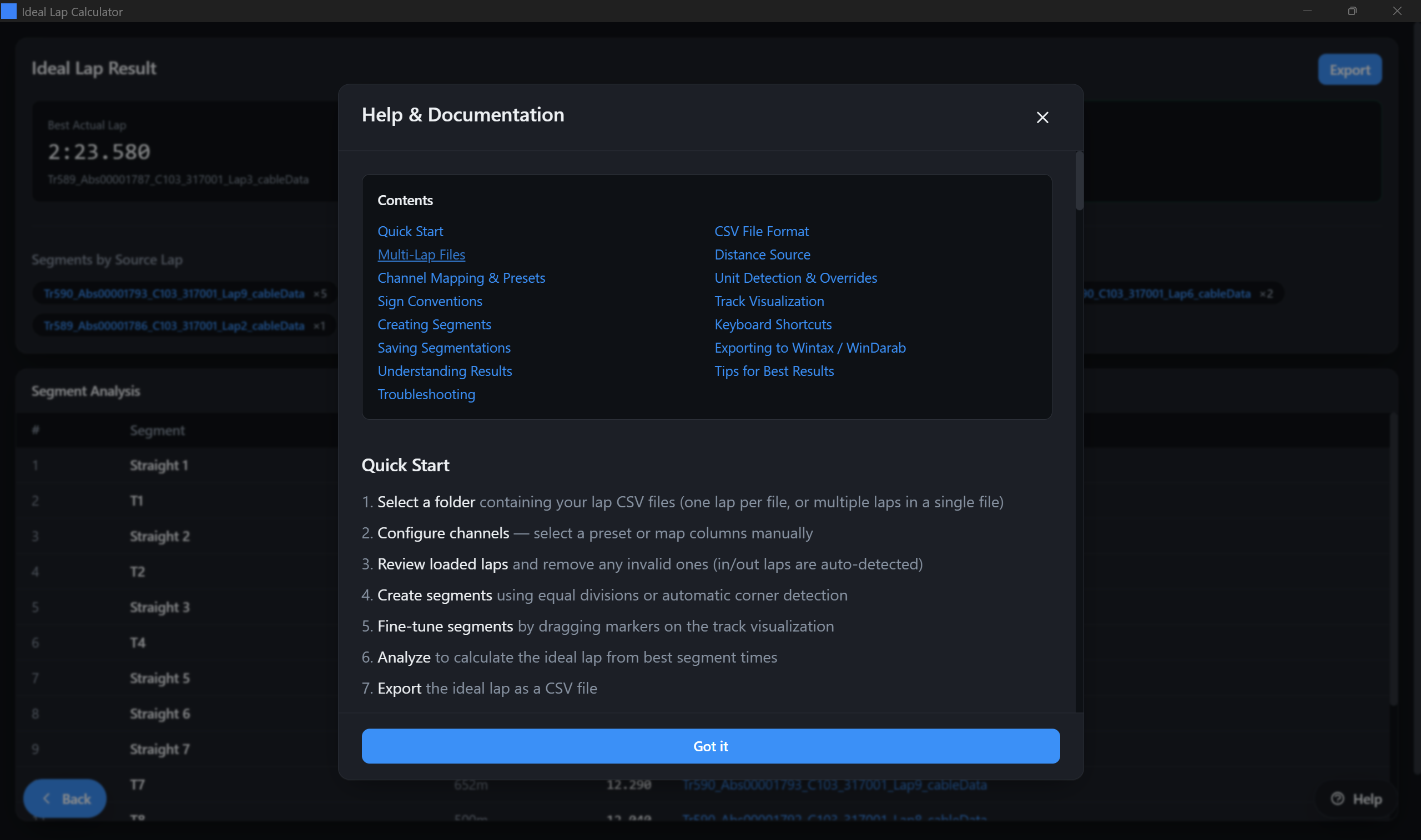
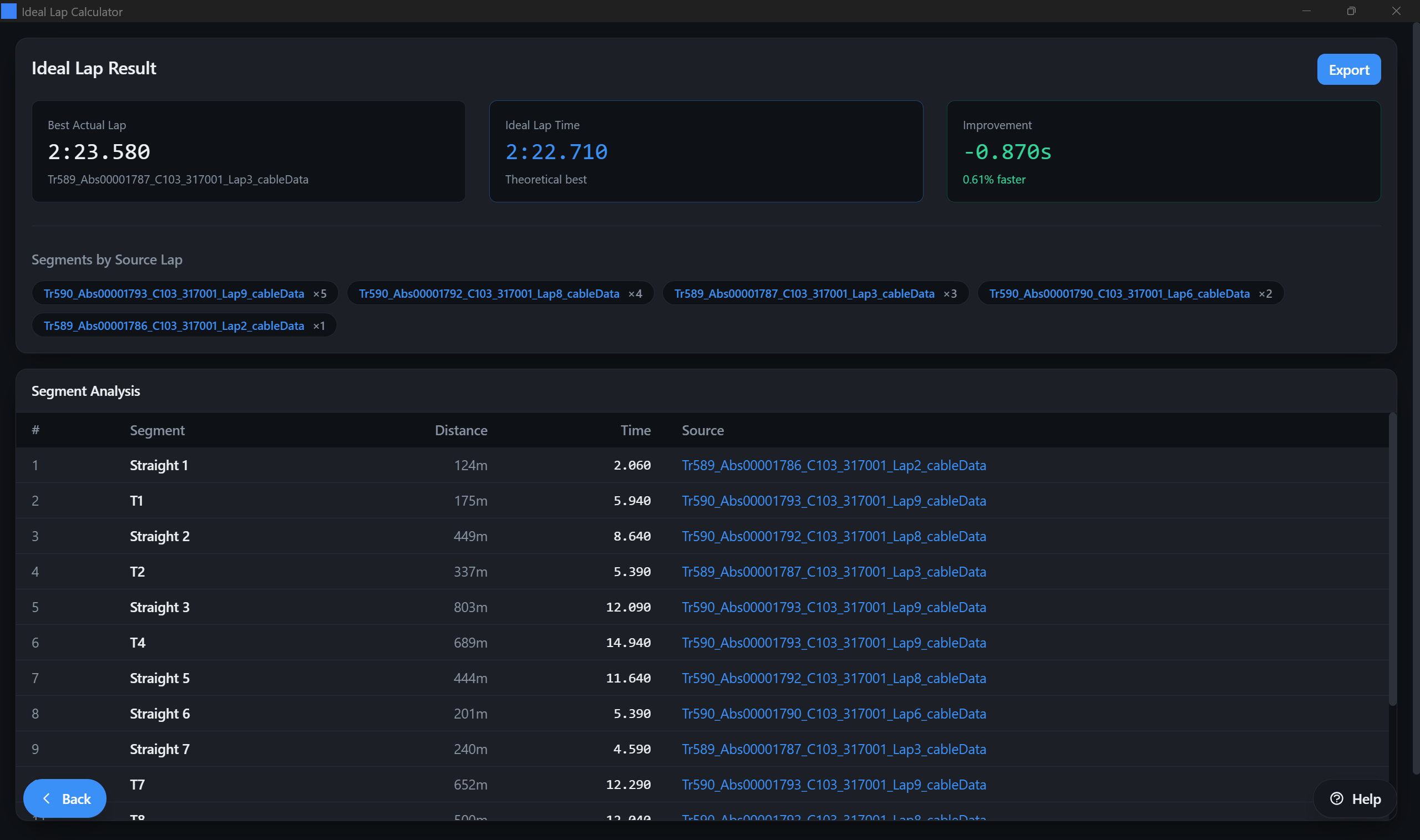
Segmentation and track editor screen
Screen 5

Ideal Lap Results

The results screen summarizes the best actual lap time, the ideal lap time, and the improvement. It also shows a segment table listing each segment's best time and which source lap produced it, plus an Export to CSV button to save the generated ideal lap.

Summary panel
  • Best Actual Lap: fastest full lap in your dataset.
  • Ideal Lap Time: sum of best segment times.
  • Improvement: delta vs best actual.
  • Segments by source: how many segments each lap contributed.
  • Export to CSV: saves the ideal lap result for use in external telemetry tools.
Segment table
  • Lists segments in order with distance and time.
  • Shows the source lap name for each best segment.
  • Use this to identify where different laps were faster.
Ideal lap results screen
Dialog

Help & Documentation (In-App)

The app includes a built-in Help modal with a quick index and troubleshooting guidance for common telemetry issues such as units, sign conventions, multi-lap splitting, and track visualization distortion.

How to open

Click the Help button in the app (it appears as a floating button on most screens).

In app help documentation dialog

CSV & Channel Requirements

IdealLapCalculator works with telemetry CSV exports from many tools. If your platform's headers are recognized, presets may be suggested. Otherwise, you'll map columns manually once and save a preset for next time.

CSV format expectations

  • Delimiter: comma or semicolon (automatically detected).
  • Decimal separator: period or comma (automatically detected).
  • One lap per file or multiple laps per file are both supported.
  • Time column: if missing, a sampling frequency can be used as a fallback.

What the app needs

Required for analysis
  • Distance (from a channel, or calculated from Speed x Time)
  • Longitudinal G (for auto segmentation and braking overlays)
  • Lateral G (optional for segmentation, and used for reconstructed fallback when yaw rate is unavailable)
Required for track map (choose one)
  • GPS mode: latitude + longitude
  • Reconstructed mode: speed is required; yaw rate improves quality when available
Optional but important
  • Lap number (for multi-lap CSV files)
  • Brake / throttle / steering (not required for ideal lap calculation, but may improve context and export workflows)
Multi-lap CSV exports

If your telemetry software exports an entire session into one CSV, map an optional lap_number column so the app can split laps reliably. The app may also detect multi-lap data from distance patterns and prompt you when needed.

Track Visualization

The track canvas is used for segment editing and for building an intuitive mental model of where time is found. The app chooses the best available track source based on your mapped channels.

GPS

Uses latitude/longitude coordinates for the track map. Best accuracy when your data includes GPS.

Reconstructed (Yaw Rate)

Uses available telemetry to draw a usable track map without GPS. Requires correct units and sign conventions for best results.

Reconstructed (Fallback)

When fewer channels are available, the app can still visualize the lap path. Expect lower accuracy; focus on segmentation utility.

Track coloring (braking intensity)

The track path can be colored by braking intensity using longitudinal acceleration: blue indicates normal running, yellow indicates light braking, and red indicates heavy braking. If braking colors look inverted, correct the sign convention in Channel Assignment (advanced options).

Segmentation

Segments define the parts of the lap you want to compare. More segments give more detail, but extremely high segment counts can reduce clarity. A practical range is typically 12-30 segments, depending on the track and data quality.

Manual segments (equal distance)

Split the lap evenly by distance:

  • By count: you choose the number of segments.
  • By length: you choose meters per segment and the app derives the count.

Best for: consistent reporting, quick "where is time" scanning, and use cases where auto-detect is not desired.

Auto-detect (braking threshold)

Automatically proposes boundaries about 100 m before longitudinal braking-threshold crossings. Adjust sensitivity to get more or fewer segments, then fine-tune manually.

  • Lower threshold = more segments (more sensitive).
  • Higher threshold = fewer segments (less sensitive).
  • Candidates within 100 m of an existing boundary are skipped.
  • Detection re-arms after about 50 m of positive longitudinal G.
  • Use manual dragging to place boundaries at entry/apex/exit.

Best for: driver coaching, corner-by-corner comparisons, and building a meaningful "ideal lap" target.

Manual editing

Select a segment boundary and adjust it precisely. Drag on the track or edit distance values directly in the segment list.

Keyboard shortcuts
  • Delete / Backspace: remove selected boundary
  • Escape: deselect / close dialogs
  • Double-click: add boundary
Save & reuse

Save segmentations by track name. Saved segmentations store boundaries by distance, so they can be reused across laps on the same layout.

Understanding Results

Results are designed to answer two questions:

Summary metrics

  • Best Actual Lap: your fastest full lap time in the set.
  • Ideal Lap Time: sum of the best segment times.
  • Improvement: difference between ideal and best actual (seconds and percent).

Segment sources

The segment table is where the coaching insight lives:

  • Each row shows which lap produced the best segment.
  • If many segments come from different laps, your pace is there. Consistency is the challenge.
  • If most segments come from one lap, your fastest lap is close to your theoretical.

Use-case: driver coaching

Export the ideal lap and overlay it in your telemetry suite to compare against a real lap. Use the source segments list to find which lap's technique is worth replicating in each area.

Exporting Your Ideal Lap

Export creates a CSV representing the ideal lap data so you can import it into other telemetry tools and overlay it against real laps.

Export workflow

  1. Click Export on the results screen.
  2. Choose a save location and filename (e.g., ideal_lap.csv).
  3. Import the exported CSV into your telemetry tool as a normal lap.

Import notes (Wintax / WinDarab)

  • Use the correct separator and decimal settings that match the exported file.
  • Use the same sampling frequency you use for your real lap CSVs.
  • If distance plotting behaves unexpectedly, verify that your distance channel has been imported and select it in the special channels to force the software to re-compute the correct distance.

Privacy & Offline Operation

Telemetry stays local

Telemetry import, track visualization, segmentation, and ideal lap calculation are performed on your machine. There is no data being shared online.

Licensing

License activation/validation may require internet access depending on your license configuration. When available, an offline grace period may allow continued use without a connection for a limited time.

Troubleshooting

Most issues come from channel mapping, units, sign conventions, or multi-lap splitting.

The track looks distorted / squashed +

Confirm the correct units for speed and yaw rate (if used). If you're using non-GPS visualization, verify sign conventions.

Try switching distance source to Speed x Time for better synchronization when applicable.

Units were detected incorrectly +

Open Channel Assignment, then Advanced, then Unit Overrides and set the correct units for your dataset.

Braking colors look inverted +

In Channel Assignment, under Advanced, flip the longitudinal acceleration convention so braking is interpreted correctly.

Multi-lap file is not splitting correctly +

Map the optional lap_number channel. Ensure it contains integer values that increment each lap.